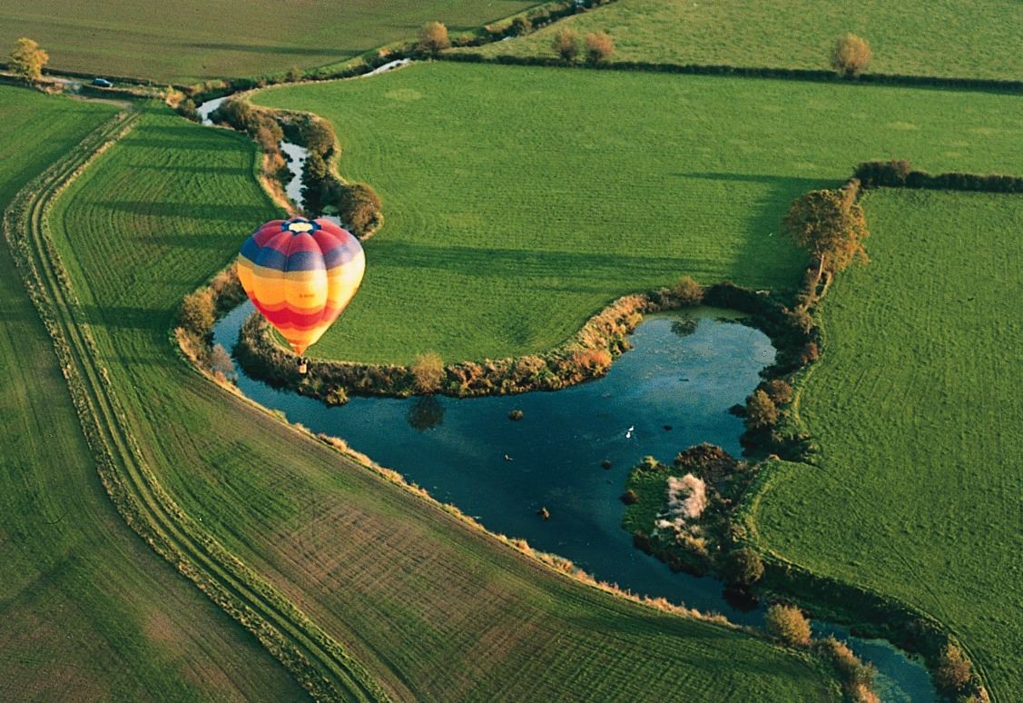
The River Parrett Trail isa scenic 50-mile walk that can be enjoyed over three to four days or as a series of shorter walks exploring some of lowland England’s most beautiful, intriguing but also fragile countryside.
Discover the gentle hills of Dorset and Somerset borders and across the wetlands of the Somerset Levels and Moors. It is also a fascinating journey through orchards, woods, withy beds and the watery haunts of birds and fishermen; passing limestone cottages, Georgian terraces, elegant mediaeval churches, and the elaborate pattern of rhynes and water courses of the lowland.
Trail highlights include Ham Hill Country Park– the site of one of Europe’s largest Iron Age hill forts –Burrow Mumpand Athelney – where the Saxon King Alfred found a refuge from the Vikings – and Steart Marshes – a wild, wetland landscape for the future that helps people and wildlife adapt to climate change.
Walking routes & videos
Scroll to the routes and maps section at the bottom of this page to download the free walking section route guidance as well as useful videos for hints and tips.
The written route instructions have been recently updated by experienced ramblers and are being continuously looked after on the ground by Somerset County Council, South Somerset District Council, local parish councils and a tireless team of volunteers throughout Somerset, to whom we are extremely grateful. Please go to our FAQs on this page if you need to report a problem on the route.
Depending on your level of experience with walking, we do advise to take the relevant OS Map with you to support the written route guidance instructions and section map overview.
Looking for places to stay?
You may wish to stay in one or a few places along the trail. Go to our STAY section of the website and click the map view. This is a great way to view the area, see some of the places to stay and where to eat and drink all at once. Our free Things to Do Guide also has a great selection of places to visit and food and drink options.
Travelling around the area...
South Somerset and the wider Somerset area offers great public transport links; for the latest information and useful links, please visit the Directions section in Visitor Information on this page.
Trail highlights...
Kick back and enjoy this short film that captures some of the wonders of the trail to discover. We are thrilled to have worked with one of the UK's nationally acclaimed folk artists and Somerset resident, Kitty Macfarlane, whose song Man Friendship is the perfect soundtrack for the trail's wild and natural beauty.
Connect & Share your River Parrett Trail walk, pictures and experience with us on our channels Instagram, Facebook and Twitter using the hashtags:
#RiverParrettTrail #visitsouthsomerset
Contact Details
The River Parrett Trail, Somerset, United Kingdom, TA10
Download your free River Parrett Trail route guidance
Discover the trail in bite-size sections; take your time to savour the incredible landscapes, history, heritage, nature and wildlife.
Depending on your level of experience with walking, we do advise to take the relevant OS Map with you to support the written route guidance instructions and section map overview.
For your convenience, you can download the whole trail as one leaflet with maps and guidance, or in individual sections.
Important note, Section 5 (Langport to Bridgwater), between Stathe and Burrowbridge.
The Visit South Somerset route follows the east bank of the River Parrett from Stathe until Burrowbridge where it exits on to the road beside the King Alfred Inn and crosses the bridge before heading north on the west side of the river.
Note that the current editions of paper and mobile OS maps show a longer route which passes the Coates English Willow Baskets Visitor Centre. The trail leaves the River Parrett at the bridge near Stathe Farm and follows the road through Stoke St Gregory to Meare Green Court (Coates English Willow Baskets Visitor Centre) and then over Windmill Hill before following the River Tone and joining the road at Burrowbridge.
Short Section Films and Trail Tips by Dot Walford
Dot Walford's passion, knowledge and enthusiasm for The River Parrett Trail is infectious! Dot is both a retired Blue Badge Guide and qualified Hill Walking Leader. With 20 years of experience, she has navigated with groups in the Welsh Mountains and on Dartmoor, and has walked in the Pyrenees.
Introduction to the River Parrett Trail by Dot Walford
Chedington to Merriott, Section One
Merriott to Ham Hill, Section Two
Section 3 - no film, please refer to PDF route guidance as this is an alternative option on the trail.
Ham Hill to Langport, Section Four
Langport to Bridgwater, Section Five
Bridgwater to Stert Point, Section Six
Dot has recently recorded her knowledge and memories in her book Somerset’s 50 mile Parrett Trail, available to buy in various local outlets including our South Somerset Visitor Information Centre & Gift Shop at Cartgate Picnic Site.
For more information about Dot and to purchase her book, please email: westcountrywalkingtrails@btinternet.com
All you need to know to enjoy your visit
Visitor Information
Discover The River Parrett Trail
The hills that South Somerset shares with Dorset are a complex medley of rocks that were laid down on ancient sea beds, raised up and now being worn down by the rain and frost and taken back to the sea by the rivers. Most of the buildings of this area are made from the lovely hamstone, a golden limestone, laid down some 170 million years ago in a warm Jurassic sea. If you look carefully, into the stone you can see the edges and fragments of countless seashells that shared these primeval waters with sea-going dinosaurs.
The River Parrett begins its journey back to the sea as rainwater percolating down through the greensand ridge at Chedington, until it meets an impervious band of clay and runs out of the ground as a series of springs. No river has a singe source; the Parrett is fed by many springs at different places. Those at Chedington are simply the furthest from the mouth – there is mild disagreement in the village as to which spring is the ultimate source.
In the hills the Parrett stream meets other streams to become a river. On the Levels it joins other rivers which flow together in a clay lined basin – bounded by hills and hemmed in from the sea by a ridge of clay.
Into this basin, over the millennia, the rivers deposited countless tons of rich silt, making it shallower still; lush vegetation grew up, not quite decaying away, creating layers of peat. This was the making of the wetland.
This wetland world of swamp and open water of three thousand years ago would have teemed with life. Flocks of pelican would have fed on the shoals of fish that thrived in the soupy water and birds thronged the reed beds and willow-fringed edges of the mere. People hunted and fished from boats and grazed their animals on the lush pasture of the damp low-lying land. The heron waited for the eel, as it still does.
Today the land still floods. The tides of the Bristol Channel have the second highest range in the world and during periods of high rainfall when the tides are at their fullest and pushing in from the mouth, the river swells and spills over its raised banks flooding the winter fields. The land returns to a memory of its former self, hills become headlands, gentle rises reveal themselves as islands, thousands of migrating water birds fly in to take advantage of the watery feeding grounds.
Every summer for as long as people have lived in these landscapes, they have brought animals down to feed on the lush, moist, peat rich pasture of the low land, retreating again when the winter came, bringing flood and rain. Somerset derives its name from the saxon ‘Summer Saeta’ which means ‘land of the summer people’.
Enjoying our Countryside, Parks and Landscapes
Please do familiarise yourself with the Countryside Code. Thank you.
Please see the individual route descriptions for car park information. There are plenty of car parks near to the trail near in local villages and towns.
For council owned car parks, you can see the list here:
Traffic on country roads can be dangerous to people and wildlife, so we ask visitors to consider the following please.
Slow down and drive carefully on rural roads. Make sure you do not block access to gateways or driveways when parking. Always leave access for emergency vehicles.
Consider leaving your car at home when visiting the outdoors. You could use public transport instead. Find public transport information on the Traveline website.
Take extra care and stay alert where a right of way crosses a railway line. You can find guidance on safely using level crossings on the Network Rail website.
Face oncoming traffic and follow The Highway Code when you walk on a road without a pavement.
Dogs are welcome on many parts of the trail and there are some lovely dog friendly walks right across South Somerset. We ask that everybody considers the Countryside Code when enjoying the trail with their dogs:
Please keep your dog under effective control to make sure it stays away from wildlife, livestock, horses and other people unless invited. You should:
always keep your dog on a lead or in sight
be confident your dog will return on command
make sure your dog does not stray from the path or area where you have right of access
Always check local signs as there are situations when you must keep your dog on a lead for all or part of the year. Local areas may also ban dogs completely, except for assistance dogs. Signs will tell you about these local restrictions.
It is good practice wherever you are to keep your dog on a lead around livestock.
On Open Access land and at the coast, you must put your dog on a lead around livestock. Between 1 March and 31 July, you must have your dog on a lead on Open Access land, even if there is no livestock on the land. These are legal requirements.
Always clean up your dog’s poo because it can cause illness in people, livestock and wildlife.
Never leave bags of dog poo around, even if you intend to pick them up later. Deodorised bags and containers can make bags of dog poo easier to carry. If you cannot find a public waste bin, you should take it home and use your own bin.
Thank you.
There are some wonderful pubs, cafes, and farm shops en-route to keep you fuelled for your adventures on the trail. Take a look at the route guidance for some ideas on where to find them and some are listed on our website too in the Food and Drink section.
You can also click on the map view in the Things to Do section of our website, which will give you a useful overview of nearby places to visit. You'll find even more ideas in our free Things to Do Guide.
Please refer the the individual route descriptions for this information.
Public toilet facilities can be found in some of the places along the trail. For latest details of these, please visit South Somerset District Council's website:
The River Parrett bustles with activities and river life.
At Langport, you can launch your own craft such as canoes, kayaks and paddleboards, or take a leisurely scenic trip on the Duchess of Cocklemoor (a restored River Dart ferry). There are modern pontoons for mooring to and swimming from and, if you are an angler, you can cast a line from new fishing platforms and accessible towpaths. Along the riverbank there are picnic areas and fitness apparatus, with interpretation boards crammed with fascinating information about this unique countryside.
For more information about activities and necessary licences you may need (fishing / canoe) please check the information boards and / or visit Langport Town Website.
Discover more here in this short film:
Bridgwater & Taunton Canal
The Canal & River Trust has created some great activities to do in this area. Click here to find out more and to access free activity leaflets too.
Please note that most of the trail is not accessible for cycling; public footpaths are not for cycling and we ask that you obey the local signage please.
There are parts surrounding the trail that are great to explore on two wheels too, and Parrett Trail Bikes in Langport offers local hire services.
You'll also find a great variety of free trails and routes to download on our website in the Things to Do, Cycling section, including Pedalling the Scenic Route, which includes routes starting in the heart of Langport.
There will be limited accessibility in parts of the trail due to stiles / gates and the rural nature of the walking trail.
There are however parts of the trail with excellent accessible terrain. Langport is particularly flat and with its recent regeneration programme, the river front provides an excellent scenic walking route.
Ham Hill also has an accessible walking trail.
Steart Marshes is also accessible.
For additional accessibility information about visiting South Somerset, including accessible walking trails, please refer to our Accessibility Guide that we hope will provide some useful information in planning your stay.
South Somerset and the wider area benefits from good public transport facilities.
Our Travel and Transport information page lists many local bus, coach and train services, together with other useful pointers about travelling in the area.
You are bound to see herons on the Levels, but the eel, which the heron waits for, that lives in countless numbers in the river and rhynes you may never see. There have always been otters on the Parrett but you would need incredible luck or patience to see one. You may see a roe deer bounding through a field, but look across a meadow where there are several hares, crouched still like clods of earth, and you may not see them at all.
Thanks to the Great Crane Project, you'll often see these in autumn and winter in the fields and flying majestically above your head!
The warmth and moisture of the Levels means that vegetation grows prodigiously, rhynes left unmanaged quickly clog with plants. The older grassland and edges of the droves flush with the colours of a succession of flowers – celandine, lady’s smock, meadow sweet, meadow rue and Queen Anne’s lace. Marsh orchids edge the ditches. Despite its ecology being complex, diverse and fragile, it is also a place where people need to make a living.
Eels as tiny elvers, born in the Sargasso Sea, some 4000 miles away, arrive in their millions at the mouth of the Parrett every spring. If they survive the elver fisherman, and while they grow in their muddy feeding grounds – they will make the return journey to spawn.
The essential few inches – specialist feeders like the curlew rely on insect life being forced to the top few inches of soil by high water levels to be able to feed.
You may not see the otter but you may well find a footprint in a muddy place and know that the otter isn’t far away. Note that the otter, like the badger, has five toes, which distinguishes it from the dog that has four.
On West Sedgemoor, the RSPB maintains the diversity of the wetland as it was pre-war. Delight in the trill of skylarks high above the meadows and listen for warblers in the ditches. In winter marvel at the numbers of ducks feeding out in the fields and watch as they are spooked up into the air by a passing bird of prey. No attempt should be made to cross this moor from Stoke St Gregory but on the Southern Side of the moor you can visit the RSPB bird hides and the heronry – spectacular in spring at Swell Wood.
The Bridgwater Bay National Nature Reserve, at the end of the trail, is the largest area of saltmarsh in Somerset and part of the Severn Estuary, the estuary of the River Severn, the longest river in England. Plus, its mudflats, sand banks and saltmarshes are nationally and internationally important feeding and nesting sites for waterfowl and wading birds.
How do I report an issue?
Many footpaths, bridleways and other public rights of way cross private land, working farms and in some cases are close to private homes. Please keep to the paths, keep your distance from landowners, and if you have a dog with you, keep it under close control (on a short lead or at heel). Continue to follow the restrictions and measures which are in place to protect you and others. Care must also be taken when approaching animals with their young.
If you come across an issue on the network please check to see if it is already reported at Explore Somerset before adding it as an issue.
You can use Explore Somerset mapping to report issues that you find on the public rights of way network. Please locate the issue on the map as accurately as possible as this makes it easier for the wardens and rangers to locate and investigate. Issues will be assessed and where necessary, action taken to try and resolve them. If you supply your email address on the form you will receive updates when the issue has been assigned and resolved or closed.
If you haven’t found what you need, or need more support please email: RightsofWay@somerset.gov.uk
Click here for more information about reporting an issue.
We use cookies to give you the best possible experience on our website. By continuing to browse this site, you agree to our use of cookies. For more information, including how you can amend your preferences, please read our Cookie Policy.


 In the hills the Parrett stream meets other streams to become a river. On the Levels it joins other rivers which flow together in a clay lined basin – bounded by hills and hemmed in from the sea by a ridge of clay.
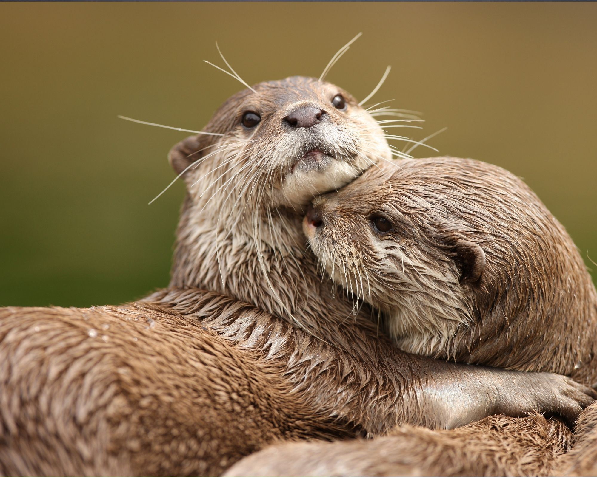 You may not see the otter but you may well find a footprint in a muddy place and know that the otter isn’t far away. Note that the otter, like the badger, has five toes, which distinguishes it from the dog that has four.
